The History of The Aral Sea
A Tragic Past, A Fascinating Present
The Aral Sea disaster is one of the most tragic environmental stories of our time. Once the fourth largest inland sea in the world, today it has virtually disappeared from the map, leaving behind a desert, a dried-up bed, and a host of unresolved problems. This story has come to symbolise how unwise management of natural resources can lead to catastrophic consequences.
Since ancient times, the Aral Sea has been an important source of water and food for the people of Central Asia. Its waters were teeming with fish, and coastal towns prospered from fishing and trade. In the Middle Ages, the caravans of the Silk Road passed close to its shores, and local residents built their lives around this natural wonder. However, everything changed in the 20th century when people decided to use the rivers feeding the Aral Sea for irrigation of agricultural land. The history of the Aral Sea is a reminder of how human intervention can alter landscapes forever.

In the 18th and 19th centuries, the sea served as a strategically important source for the Russian Empire and later for the USSR. Military bases and ports were located on its shores, and in the mid-twentieth century, a secret complex for testing biological weapons was built on Vozrozhdeniya Island. After shallowing, the island became part of the land, which created new ecological and epidemiological threats.
The main reason for the disappearance of the Aral Sea was the large-scale use of the waters of the Amu Darya and Syr Darya rivers for cotton farming. During the Soviet era, large irrigation projects were launched to increase cotton production. These projects led to a catastrophic decrease in water inflow to the sea. The Aral Sea before and after these projects shows the stark difference between a thriving ecosystem and an environmental catastrophe. In the 1960s, water levels began to drop rapidly, and by the beginning of the 21st century, the sea was divided into several small bodies of water, most of which soon dried up completely.
In addition to the anthropogenic factor, climate change and rising temperatures contributed to accelerated evaporation of water. Summers became hotter, rainfall decreased, and the Aral Sea lost its ability to recover.
The disappearance of the Aral Sea has led to the destruction of the region’s ecosystem. Previously fertile land became saline and infertile, making it unsuitable for agriculture. Due to the evaporation of water, salt and sand storms became a frequent occurrence, carrying toxic particles thousands of kilometres away. This has led to a deterioration in the health of the local population, with an increase in respiratory diseases, skin diseases, and cancer.

Biodiversity in the region has declined dramatically. Many fish species have disappeared, and birds that previously used the reservoir as a stopping place during migration have been forced to find new routes. Residual water bodies became too salty for most aquatic organisms, becoming dead zones.
The loss of the sea has destroyed the fishing industry that employed tens of thousands of people. Cities that used to be on the coast, such as Muinak, have become ghost towns. Mass unemployment forced many locals to leave the region in search of a better life.
Agriculture, dependent on irrigation, faced serious problems. Soils have lost fertility and salinisation has destroyed much of the crops. The water that flows to the remaining oases is often contaminated with pesticides and chemical fertilisers, with negative effects on human health.
Despite the dire situation, attempts are being made to partially restore the Aral Sea. In Kazakhstan, the Kokaral Dam was built, which allowed preserving a part of the Small Aral Sea. This made it possible to revive fishing in some areas, and the water level in some places began to rise. However, full restoration of the entire Aral Sea remains unlikely due to global climate change and continued use of water resources.

Some international organisations fund projects to combat desertification. The planting of drought-resistant plants such as saxaul helps to partially contain sandstorms and stabilise the soil. The Aral Sea tour industry is slowly developing, as visitors seek to witness the remains of this once-great body of water and the remnants of fishing towns.
Unique finds and facts:
- Prehistoric sharks: scientists find ancient shark teeth, confirming that millions of years ago the region was part of the ancient Tethys Ocean.
- Aralkum – the new desert: a new desert has formed in place of a dried-up sea and has been studied by climatologists and biologists.
- Rusty ships in the sands: the remaining ships on the former seabed have become a symbol of the catastrophe and attract tourists and photographers from all over the world.

The Aral Sea is not just a vanished body of water, but a story of how human interference in nature can have irreversible consequences. It serves as a warning to future generations about the importance of rational use of natural resources. Despite the tragedy, the region lives on and recovery efforts offer hope for a better future. However, only an integrated approach with international co-operation and responsible water management can help prevent similar disasters in the future. Visitors who embark on an Aral Sea tour often leave with a deep appreciation for the resilience of the people and the reminder of what happens when nature is mismanaged.
Muynak
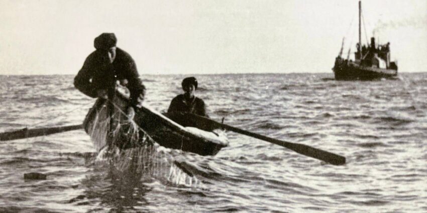
Muynak, once one of the largest port cities on the shores of the Aral Sea, was an important centre for fishing and fish processing. During the Soviet years, it prospered, supplying the entire region and exporting fish to various parts of the USSR. Fishing flotillas of hundreds of vessels went to sea every day, and local fishermen worked in difficult but productive conditions, providing their families with a stable income.
Large fish processing plants, such as the Muynak fish processing plant, which was one of the most powerful in Central Asia, operated on the shores of the city. Here they processed sturgeon, carp, pikeperch, produced tinned fish, dried fish, fish meal, and fat. The factories provided jobs for thousands of residents, and life in the city was thriving: new houses, schools, hospitals, cultural institutions, shops, and cinemas were built. The fish industry provided not only for the local population, but also supplied fish to many regions of the Soviet Union.
However, by the middle of the 20th century, the situation began to deteriorate rapidly. Massive water withdrawal from the Amu Darya and Syr Darya rivers for irrigation of cotton fields led to reduction of water inflow to the Aral Sea. As the water receded, so did life in the city. By the 1980s, the sea was tens of kilometres away from the city, leaving behind a desert and rusting ships on the former seabed.

The fishing industry was in decline. Factories closed, the flotilla fell into disrepair, and thousands of fishermen and workers were left destitute. Many families were forced to leave the town in search of work, leading to a mass exodus. Muynak, once a thriving industrial hub, became a near-deserted outpost, surrounded by endless salt sands.
Today, Muynak resembles an open-air museum. Rusty ships stuck in the sands of the former seabeds have become one of the main tourist attractions in the region. They symbolise the consequences of Central Asia’s biggest environmental disaster. The remaining inhabitants are trying to adapt to the new conditions: some are engaged in agriculture, others are developing tourism. Every year, festivals, exhibitions, and events are organised to draw attention to the problem of the drying Aral Sea.

Despite the harsh conditions, the local population retains a spirit of resilience. Some former fishermen who have lost their profession have found alternative ways of earning a living through crafts, trade, and agriculture. However, many continue to hope that the Aral Sea will at least partially return, reviving lost industry and bringing new opportunities for the region.
In recent years, attempts have been made to revitalise the region. Kazakhstan’s Kokaral Dam has helped to partially restore water levels in the Small Aral, allowing the return of fisheries to some areas. For Muynak, however, the process has been slow. The government and international organisations are working to improve living conditions, introduce programmes to combat desertification, and develop eco-tourism.

Projects are being set up to attract investment in ecotourism, produce handicrafts, and rehabilitate parts of the fishing industry to support local residents. Some enthusiasts are even organising small lake farms in the hope of restoring the fishery.
Muynak is a living reminder of how the unsustainable use of natural resources can change the fate of an entire town. Its story is as much an example of human resilience as it is a tragedy. Despite the losses, residents continue to fight for the future of their city, and Muynak remains a symbol of hope and rebirth. Perhaps one day the sea will return to its shores and the fishermen will sail again, continuing the traditions of their ancestors.
Barsa Kelmes
Barsakelmes: The Island That Disappeared with the Sea
Mysterious Name and Myths:
Barsakelmes, which means ‘you go – you will not return’ in Kazakh, evokes both fear and curiosity through its very name. Many legends and myths are connected with this place. Some say that time flows differently here. Others claim that abnormal phenomena related to the disappearance of people took place on the island. In Soviet times, expeditions came here to record unusual phenomena, which only fuelled interest in the region.
History and Significance
Barsakelmes was the largest island of the Aral Sea and was located approximately in the centre of the reservoir. In the early 20th century, small settlements were built here, used for nature observation and salt mining. In 1939, the island was declared a nature reserve and became home to rare animals, including kulans and saigas. In the absence of predators, their population grew and the island’s ecosystem flourished.
For several decades, the Barsakelmes Reserve was considered a unique natural site where animals could live in relative isolation. However, as the Aral Sea dried up, the island gradually became a peninsula and then merged with the mainland, resulting in a disruption of the ecosystem. Many animals either migrated or died due to lack of water and changing habitat conditions.
Ecological Disaster
As the sea began to recede, Barsakelmes became trapped. Freshwater springs disappeared, soils became saline, and vegetation died. Gradually, the island became uninhabitable. The reserve ceased its activities and animals left the area in search of more favourable conditions. Today, the former island is a deserted piece of land covered with salt marshes and sands left by the dried-up sea.

In addition to the destroyed ecosystem, Barsakelmes has also been exposed to toxic sediments. Evaporation from the former seabed contains pesticides, heavy metals, and salts that are carried hundreds of kilometres by the wind. This has caused an increase in illnesses among the local population and a general deterioration of the ecology of the region.
Current Status
Today Barsakelmes officially remains a nature reserve, but its status is rather symbolic. Scientists continue to study its territory, recording changes in climate, geology, and flora. Due to the inaccessibility of the area, only a few exceptional expeditions venture here. However, interest in this place does not fade – Barsakelmes remains a mystery, attracting researchers, historians, and fans of anomalous phenomena.
Despite the destroyed ecosystems, work is underway to restore some of the flora and fauna. Experiments are underway to artificially breed plants that are resistant to salinity, and the possibility of creating closed water reservoirs to support animal life is being considered.
Barsakelmes is not just a former island, but a symbol of the disappearance of an entire ecosystem, along with the Aral Sea. Its history is a reminder of how fragile nature is and how important it is to cherish its resources. Today, it remains part of the larger ecological puzzle of Central Asia, and its fate depends on further conservation initiatives and scientific research.

Ustyurt Plateau: An Ancient Trace of Nomads in the Vast Steppe
Unique Landscape and Natural Heritage
The Ustyurt Plateau is one of the most mysterious places in Central Asia, situated between the Caspian Sea and the Aral Sea. It stretches across Kazakhstan, Uzbekistan, and Turkmenistan, and is a rugged but mesmerising landscape of sheer cliffs, deep gorges, and endless steppes. This place is famous for its ancient petroglyphs, indicating human presence since prehistoric times.
The flora and fauna of the Ustyurt Plateau are unique. Rare species of animals, such as the Ustyurt mouflon, caracal, and steppe eagle, can be found here. Despite its seeming lifelessness, the plateau has great biodiversity and its ecosystem is adapted to extreme climatic conditions.
Ancient Nomads and Funeral Rites
The Ustyurt Plateau has long been a crossroads of nomadic routes linking Eastern Europe, the Middle East, and Central Asia. The great caravans of the Silk Road passed through its expanses, and nomadic tribes used it for grazing and seasonal crossings. Here one can find traces of ancient settlements, burial mounds, remains of watchtowers and fortifications used for defence against raids.
Of particular interest are the burials scattered throughout the plateau. For thousands of years, nomads buried their dead in these harsh lands, creating stone tombstones and burial mounds. Some of them are decorated with symbols, mysterious drawings, and runic inscriptions, testifying to the ancient beliefs and traditions of the steppe peoples.

Mysteries and Research
The Ustyurt Plateau is still an object of research by archaeologists and historians. Remains of ancient towns and sites, traces of nomadic civilisations, as well as old caravanserais, which served as a shelter for travellers, have been discovered on its territory. Scientists continue to find burial and ritual sites, studying the culture and life of the people who inhabited these lands for thousands of years.
It is believed that some of the ancient peoples who lived here disappeared, leaving behind only stone slabs with inscriptions and sacred places that still keep their secrets. Today, the plateau continues to attract not only scientists, but also travellers seeking to discover the rugged beauty of this vast steppe.
Current State and Future
Today, the Ustyurt Plateau remains a sparsely populated region with inaccessible areas, which allows it to preserve its pristine nature. However, climate change, human activity, and desertification threaten its ecosystem. Work is underway to study the region and to develop programs for its protection and rational use.
The Ustyurt Plateau is a living legacy of ancient civilizations, keeping in itself the memory of the past and mysteries that are yet to be unravelled. Its harsh but majestic landscape remains a mute witness to thousands of years of history, reminding us of the greatness of nature and the inseparable connection between man and the earth.
Now that you have a deeper understanding of the history of the Aral Sea, why not experience it firsthand? Our 2-Day Aral Sea tour offers a rare chance to witness one of the most dramatic transformations on Earth. Stand in the middle of a desert that was once an ocean and explore a region where history, geography, and human resilience come to life.